[Update: So....I uploaded some picture without rotating them, and some pictures were uploaded to be left justified, centre justified and some with no justification. Because of that it jumbled up the orientation when I actually poseted this...but.....its time consuming to go back and figure out what needs to be re-uploaded and changed and, since time is dripping away and there are other things to be done, im going to leae this looking a little ugly for now. Apologies, all around. ]Another weekend in the mountains!
This weekend we made our way back to Taipei to check out yet another hiking area. Two weeks ago we landed in
PingXi village and hiked around the crags and up the ladders for a solid day and realized that there was so much to do in this area, so much that we had not yet seen. So much, that it required us to get right back on the horse and get our boots tromping around on more northern Taiwan trails. This time we hit
HuangDi Dian, and the most popular and quite spectacular
YangMing Shan National Park.
Two epic days, one on a sandstone ridge with minimal purchase on the narrow
ridge line keeping us one step ahead of gravity and its urge to draw us down the cliff
face on either side, and the other on a basalt flow turned grassland among undulating mountains in the north. Taiwan really doesn't dissapoint....
 Us, at the end of the HuangDi Temple hike and just a touch prior to us jamming our faces with...pizza!!!
 One of the peaks along the HuangDi Dian hike. Most of the trail follows a ridge line that, at many times, is sheer cliff-faced on either sides of your little sandstone pathway. Ropes help....sometimes....but not always...to cure the vertigo
!
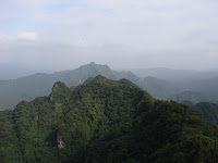
 Yangming Mountain National Park - the scenery of Taiwan in the distance from the heights of the grassland (old lava field).
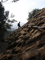
 Crystal, pausing after reaching the first summit of the HuangDi trail. Off in the distance is the southern extent (the beginning of it) of the central mountian range.
 Looking back the opposite way of the photo above, making the final steps towards the first pinnacle of the HuangDi trail - the trail follows a hectic ridge line that weaves its way through the mountains, usually a knife edge of rock to walk along.
The weekend started out without a hitch, got to Taipei, found our new hostel (half the price of every other hostel we had found, and still quite nice (enough - a bed, communal stuff like shower and kitchen, etc and a locked door). A nice
base camp of sorts for future Taipei-based hikes. Weaving around looking for a place to hang out for the evening we found a nice G
erman place, and sat down for a pint of Germany and then retired for the night. Plans made, we knew what we were going to do the next day, how to get there and we had that feeling that the weather was going to work in our favour.
But then we woke and realized that it was Taiwan, and nothing ever...ever...goes as planned. Simple enough instructions - take transit to a specific stop, grab bus 666 and get off in the middle of a well known yet tiny (300 people?) town to the northeast.
However, bus 666
doesn't stop at the station we were told to go to. So...taxi to another station. Wait. Get on bus 666....only it is going the wrong way. Get off...wait for the same 666 bus but heading out of town, not back into it. Wait. Wait. Get on. Take it to the end of the line...where the driver stopped and asked us exactly where we wanted to go.
Shiding...
HuangDi Dian. Simple enough. Town name. Hiking Trail name. No problem. Except, his bus
didn't go there. The 666 bus does go there, just he
wasn't driving his specific bus that far. Get out. Wait. Wait. Wait. A nice man who was busy making sesame oil stopped to help us figure out the bus situation....apparently only random 666 buses go past where we were. Wait. Next bus...666...no. Wait. Wait. Wait. About an hour later we get fed up and start walking towards the direction of the
trailhead....then get a taxi....then get sorta lost as the taxi driver has to stop and ask a few people at random intervals where this place is that we want to go to. Then.....finally....trailhead. Lunch, liquids, go!
And go we did! This trail is about half an hour or so of direct uphill stairs....painful and steep but the wonderful reality of reaching the top and
realizing that the majority of the rest of the trail is along a sharp
ridge line (that in part really should be illegal to hike along...Taiwanese have weird sense of danger). Hike, hike, hike....up and down roped sections...up and down ladders to get from unmanageable ridge to unmanageable ridge...stepping bravely along a backbone of the mountains that offered death on either side. Totally a wonderful, exciting and beautiful hike. Totally worth every moment of pain and confusion to get there. For the sweat drenched views, the heart pounding climbs and being on the verge of vertigo induced limb-failure at times....we will return!
Again, we must mention the care and energy that the Taiwanese have put into these hikes. Without their ladders and ropes in sections, it would be totally impassable. But with a little technology in place, a whole
ridge line is open to everyone who is willing to sweat it out to get there. The beauty of Taiwan is made open-source, so to speak.

 Waiting for the bus...on the left we wait at the MRT station bus stop for the 666 bus that would eventually take us the wrong way; on the right a scenic moment as we waited for the 'other' 666 bus that could take us the final 10 minutes or so down the road. As it never came....a taxi helped us out shortly after this pic was taken.

 Finally! Made it to the trailhead, grabbed some lunch and then started the uphill climb. Along the way a beautiful little caterpillar made a guest appearance!
 Another fine view along the forested section - post stairs, pre-peak.
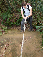
Crystal taking time to (trust) use the first roped section....its a little steeper than the picture lets on...
 The view from the top on the left, crawling along the peak (ok, I froze....calmed my vertigo and started to crawl backwards down from the peak....im not ashamed of the truth!)
 This is the approach to the first main ridge line. We finished the stairs, hiked through the woods for a short while and then finally popped out into the clear sunshine and rocky tipped peak.

 Walking along the final ridge-line section on the left, waiting to start the longer ladder climb on the right.
Sunday we awoke to another splendid day, perhaps better than Saturday. So, we hopped on the easily accessible bus and made our way north to YangMing Shan National Park. A beautiful park that is super close to the city. Good for day trips, but diverse, big and technical and exciting enough to spend a few days on an overnight journey. Someday, perhaps. Today was a day trip to an area that we wanted to explore for some time - the grasslands. Still mountains, this old volcanic area was recently - geologically - a region of extreme activity and the ground on which we walked was a well defined lava bed. Time has turned it into a biologically diverse undulating region. surrounded by ridges of mountains as far as you can see. And, if you are lucky (or unlucky) you can see Taipei itself. So close, yet in such a different world. So goes the paradox of Taiwan.

 Ahead is an extinct volcano (I do believe it is the main source of the lava flows that formed the current landscape of the area we were hiking in). Some of these mountains - the ones that are directly along the main fault - still puff out steam and provide ample hotsprings throughout the park. On the right, me standing beside the 'grass' that took over this lava field.
 Peering off towards the south-east of Taiwan, sitting on a geological wonder.
Where are we....were can we go....what is the name of that mountain....
Making it back along the trail to the bus stop...getting the bus back to the city and hopping on the train home, we (without seats, so we had a nice 3 hour ride on our arses by the door...) made it home alive and well....and pumped once again to go back and explore another nook of Taiwans vast and endless secret spots!

 On the train...three hourse of this. You will have to turn your head because I uploaded these before I realized I forgot to rotate them. Anybody versed in blogger.com will tell you that to upload a pic after writing a post is the most frustrating thing you can do, so im not deleting and re-uploading. You can use this as neck exercise!
Crystal climbng, below:
 Hualien City; to the west (left) are the foothills to the coastal mountains, and to the east (yup, the right) you can see the Pacific Ocean. Ocean to mountains, 20 minutes by bike.
 Christmas morning in our bathroom tiled kitchen and Japanese styled living room.
 The protector of the presents - Raffy.
 Liyu Lake (Carp Lake) as the sun sets on December 25th. We went for a christmas hike around the trails in this park and were lucky to end the hike at the same time the sun had just dipped behind the mountains, giving us a perfect (almost) setting for a picture.


